Drone Solutions
Construction & Inspection
Reduce costs and project overruns, improve safety, and deliver improved communication to all stakeholders!

2D & 3D Mapping
- 2D Mapping: Ideal for straightforward layouts, these maps provide a flat perspective that highlights key features, property boundaries, and spatial relationships. Perfect for presentations, planning, and quick assessments.
- 3D Mapping: High-resolution 3D models to help crews determine challenges and identify potential design flaws, preventing resource waste. 3D models can also keep the team on track with the original design and show clients what the finished project will look like.
Thermal Imaging
- Detect infrared radiation before significant problems occur, costing setbacks in time and money. Create precise mapping for construction sites for more efficient productivity and less waste or materials.
Inspections
- Drones are increasingly used to inspect infrastructure such as pipelines, power lines, buildings, and roofs. By using drones for these tasks, businesses can reduce the need for costly manual inspections, improve safety by avoiding workers needing to access hazardous areas, and identify maintenance issues before they lead to costly downtime.
Residential and Commercial Real Estate
Elevate your residential and commercial real estate marketing!
High-Resolution Images and Video - From the ground and sky!
- According to MLS data, properties leveraging aerial footage sell up to 68% faster.
- Create immersive listings, blending breathtaking drone footage with ground-level shots.
- Showcase your property's unique selling points: lush landscaped yards, sparkling pools, stunning views, and the overall layout, setting it apart from the crowd.
- Highlight convenient access to nearby amenities and transportation routes.
Agriculture, Environmental Monitoring and Urban Planning
Aerial techniques using technologies such as multispectral, and thermal imaging open a wide range of possibilities in various fields. In agriculture, it can be used for monitoring vegetation, detecting plant diseases, and identifying potential crop issues. In ecology and geology, it helps researchers study changes in wildlife populations and movement, vegetation, soil composition, landscapes, and terrain.
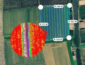
Agriculture
- Multispectral imaging can optimize crop management by monitoring vegetation health, detecting diseases early, and improving resource efficiency.
- Thermal imaging enables the identification of uneven irrigation and monitors crop water usage, allowing for optimized irrigation schedules and more sustainable water management.
- Identify when fruit is ripening to allow optimal harvesting.
- Monitor livestock health.

Environmental Monitoring
- Track ecosystem health, monitor biodiversity, and assess the impact of environmental stressors.
- Monitor wildlife diversity and movements.
Urban Planning
- Evaluate urban green spaces, detect heat islands, and monitor infrastructure conditions.